
Ierland


individuele reizen
Dingle - 5 dagen
Dingle Way, trektocht langs B&B's
zwaarte 
In het echte Ierland kan ieder pubbezoek uitlopen op een spontane zang- en danspartij. Die sfeer vindt u op het Dingle Peninsula, de meest westelijke punt van Ierland. “The Dingle Way” voert u over groene landweggetjes langs bijenkorfvormige stenen hutten en andere archeologische monumenten.
Day 1 – Arrival to Dingle
Arrival to Dingle town. There is a bus service from Tralee, or seasonal summer service from Killarney. Overnight accommodation in Dingle town.
Limber up with a local circuit walk on Ballysitteragh Hill. This is a strenuous but very rewarding walk, with fabulous views of Dingle town and harbour; on a good day you can see most of the peninsula. It is not compulsory to complete the full round trip, you can walk as far as you feel comfortable with and return the same way.
Distance 19km. Ascents 630m. Approximate walking time 6.5 hours. Short return 10km, 4 hours
Dingle harbour walk, a low level easy walk by the shoreline on the easern side of the harbour with a possble sighting of Fungi, Dingle’s resident dolphin since 1984.
Distance 6km. No ascents. Approximate walking time 2 hours.
Day 2 – Dingle to Dunquin
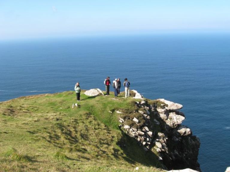
Minor roads take you from Dingle to Ventry; beyond is some of the most spectacular scenery you could hope to find. Cross the magnificent Ventry harbour, weave through fuchsia hedges and climb an old track on the foothill of Mount Eagle past the early Christian beehive huts at Fahan. Behind are views south to the Ring of Kerry and Valentia Island. Ahead the route opens up to Slea Head and the Blasket Islands. This is the most westerly point in Europe, beyond is North America!
Distance 25km. Ascents 650m. Approximate walking time 7 hours.
Optional route over Mount Eagle add 5km and 2 hours
We include notes for this climb, only advisable in good weather conditions.
Overnight accommodation in Dunquin village.
Day 3 – Dunquin to Ballydavid
We recommend a visit to the Blasket Island Interpretative Centre before departing Dunquin. The centre illustrates the harshness of life on the Blasket Islands, until the last inhabitants resettled to the mainland in 1953. Other than fishing, and sheep farming on the wind blown hills, there is little else to maintain the local communities. The walking route follows the Norse named Smerwick Harbour and a detour takes you to Dun an Oir, the Fort of Gold, where Italian and Spaniard soldiers were besieged by troops of Elizabeth 1 in 1580. Ballydavid is a thriving fishing harbour and a Gaelic speaking community.
Distance 16km. Ascents 180m. Approximate walking time 5 hours.
Optional route over Cruach Mharthain add 1 hour.
Overnight accommodation in Boherboy or Feoghanagh village. (+3-5km from Ballydavid)
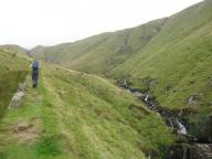
Day 4 – Ballydavid to Cloghane
You are in the cradle of early Christian civilization here, with as many as sixty notable sites of cultural and religious development from the 5th to 9th centuries. Today’s hike takes you up; up to the saddle of Mas an Tiompain (the Pass of the Drum) below Mount Brandon, Ireland’s second highest mountain at 950m. The scenery is superb – Tralee Bay, the Magharees against the hues of the Slieve Mish mountains. The descent to Cloghane is nothing short of thrilling on a clear day, and well-earned respite is available in the village!
Distance 22km. Ascents 750m. Approximate walking time 7-8 hours.
Overnight accommodation in Cloghane village.
Day 5 – Departure from Dingle
Transfer from your guesthouse in Cloghane back to Dingle town (10 minutes). Year round bus services are available from Dingle to Tralee or a seasonal service (June, July) to Killarney.
zoeken in
filteropties
extraSmallDevice
smallDevice
mediumDevice
largeDevice