
Ierland

individuele reizen
Donegal - 10 dagen
Donegal Ways, trektocht langs B&B's
zwaarte 
Donegal, een vrij onbekend stukje Ierland. Eenmaal op de Bluestack Ways zal het moeilijk zijn zich voor te stellen dat u net een druk stadje achter u heeft gelaten. Op weg naar Lough Eske loopt u langs de Ardnamona Gardens, tot ver in de 19de eeuw nog een en al wildernis, nu een Nationale Erfgoedtuin met een bijzondere verzameling bomen, heesters en rhododendrons. De overgang naar de Bluestack Mountains is indrukwekkend.
Ineens ligt deze prachtig groene bergrug (circa 675 m) voor u. U loopt door veen over verharde en onverharde paden onderlangs “Croaghorm”, de Gaelic naam voor het gebergte. Glenties en Ardarra zijn plaatsjes waar u kunt bijkomen van de stilte onderweg en een pub bezoeken om van de traditionele Ierse muziek te genieten. Het vervolg van de route brengt u naar het enige echte Gaeltacht-gebied. Er wordt Iers gesproken en oude tradities worden bewust in ere gehouden. Door veen- en heidelandschap, langs verstilde meren, baant u zich een weg naar het dramatische decor van de Slieve League. Deze indrukwekkende kliffen behoren tot de hoogste van Europa en torenen maar liefst 300 meter uit boven de golven van de Atlantische oceaan.
Day 1 – Arrival to Donegal Town
On the north eastern shore of Donegal Bay, the town is a lovely traditional town, and the county capital. Your guesthouse is situated 2km from the town at the start of the Bluestack Way. Dinner is available in your guesthouse or in Donegal town.
Day 2 – Donegal to Lough Eske
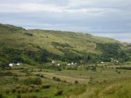
The Way follows the western shore of the lake and woodlands before climbing the foothills of the Bluestack Mountains. There are beautiful views from the Banagher saddle of Lough Eske and the mountains ahead. Follow the Eglish river valley through the drumlins of south Donegal to the deserted townlands. Your hosts will transfer you from the end of the walk back to your guesthouse.
Distance 20km. Ascents 440m. Approximate walking time 5 hours.
Overnight accommodation Donegal town.
Day 3 – Bluestack Mountians to Glenties
Your hosts will transfer you to where the walk finished yesterday. Hike to Glenties over the pass at Cloghmeen Hill through blanket bogland. Today’s walk is through more of the lowland settlements, past the pre Christian graveyard of Disert. Traverse the mountain of Luaghnabrogue to follow through the solitude of the Owenroe River to the sheep farming country south of Glenties.
Distance 13km. Ascents 370m. Approximate walking time 4 hours. Optional extra route to Lough Anna (5km).
Overnight accommodation in Glenties village.
Day 4 – Free Day in Glenties
Free day to walk in the Glenties area. Walk through lanes and boglands to the beautiful Lough Naeroaghy on the little drumlin of Derkbeg 330m. Enjoy fabulous views of the Gweebarra Bay and west to the Atlantic.
Distance 14km. Ascents 130m. Approximate walking time 4 hours.
Overnight accommodation in Glenties village.
Day 5 – Glenties to Ardara
Follow The Bluestack Way and the Owenea River to Ardara. Today’s walk follows the fishing access route to the Owrnea River on gorse lined paths with the Atlantic ahead and the mountains behind. It’s a relatively easy day’s walking and allows plenty of time to enjoy the lovely town of Ardara.
Distance 12km. Ascents 80m. Approximate walking time 4 hours.
Overnight accommodation in Ardara village.
Day 6 – Ardara to Glencolumbkille
Transfer by taxi to Maghera Strand. Follow the Slí Cholmcille along the foothills of the Slieve Tooey and Crockuna mountains to Glencolmkille. Climb by road to the top of the Owenree River valley to look down on Loughros Beg Bay, Maghera Strand and east to Ardara. The Way crosses a mountain pass at 350m to descend by road through sheep farming foothills to the gloriously remote cove of Port. What a place for lunch! (Packed…there’s nothing here but boats and gulls!) Your final climb of the day takes you up Faugher Mountain to descend to the village of Glencolumbkille. This remote and beautiful corner of Donegal is also a Gaelic speaking area and has many interesting megalithic and early Christian monuments.
Distance 20km. Ascents 630m. Approximate walking time 6 hours.
Overnight accommodation in Glencolumbkille village.
Day 7 – Free Day Glencolumbkille
Rest day in Glencolmbcille to enjoy this fascinating corner of Ireland with its many cultural and historical aspects. There have been inhabitants here since 3000BC. It has always been an Atlantic laden outpost and seat of steely determination; every culture has left their evidence. The optional walk allows breathtaking views of the Atlantic cliffs at Glen Head and Mullaghtan before the knife edge ridge of Sturrall promontory.
Distance 12km. Ascents 320m. Approximate walking time 5 hours.
Overnight accommodation in Glencolumbkille village.
Day 8 – Glencolumbkille to Cashel
Follow the Slí Colmcille to Cashel via Cornadreeshark and Crockunna hills (200m). The route to Carrick follows blanket bogland and the traditional cart tracks between the settlements. Teelin Bay is a lovely enclosed fishing harbour, a gentle introduction because over the top are the stunning, exhilarating Slieve League cliffs.
Distance 14km. Ascents 310m. Approximate walking time 4 hours.
Overnight accommodation in Cashel, near Kilcar.
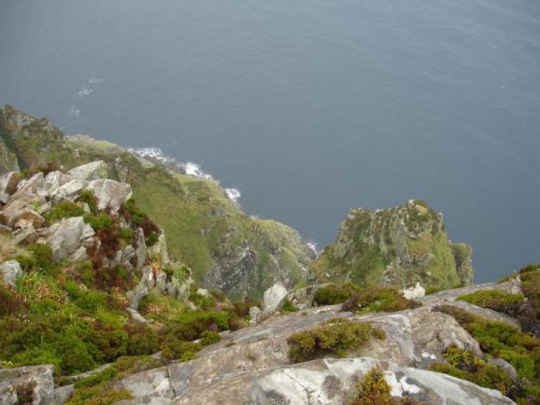
Day 9 – Slieve League Cliffs
The Belfast naturalist Robert Lloyd Praeger wrote in 1939:
“A tall mountain of nearly 2000 feet, precipitous on its northern side, has been devoured by the sea till the southern face forms a precipice likewise, descending on this side right into the Atlantic from the long knife-edge which forms the summit. The traverse of this ridge, the “One Man’s Path”, is one of the most remarkable walks to be found in Ireland – not actually dangerous, but needing a good head and careful progress on a stormy day…. The northern precipice, which drops 1500 feet into the coomb surrounding the Little Lough Agh, harbours the majority of the alpine plants of Slieve League, the most varied group of alpines to be found anywhere in Donegal.”
The cliffs are exhilarating, hair-raising and not for the faint hearted! Rising 600m from the Atlantic, they have an amazing diversity of colour and shape, as they are composed of numerous different geological types; conglomerates, schists, quartzite and some slate.
Your host will assist you with a transfer to and from Teelin.
Distance 17km. Ascents 550m. Approximate walking time 6 hours.
Overnight accommodation in Cashel, near Kilcar.
Day 10 – Departure from Kilcar
Scheduled bus services from Kilcar to Donegal for onward connections.
zoeken in
filteropties
extraSmallDevice
smallDevice
mediumDevice
largeDevice